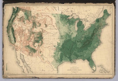
 “United States, Showing the Relative Average Density of Existing Forests.” From Department of the Interior, Census Office,Sixteen Maps Accompanying Report On Forest Trees Of North America, By C.S. Sargent, 1884.
Twenty years after the Civil War, an officer in the Union Army and professor of horticulture at Harvard University published a set of 16 tree maps that visualized tree cover and the spread of tree species in America.
The maps, the work of Charles Sprague Sargent, “provided the basis for conservationists and politicians to wrangle over issues of preservation and planning” until the passage of the McSweeney-McNary Forestry Research Act of 1928 made the process of monitoring forest conditions law, according to Slate.
To see all the maps available in the collection, click here.