


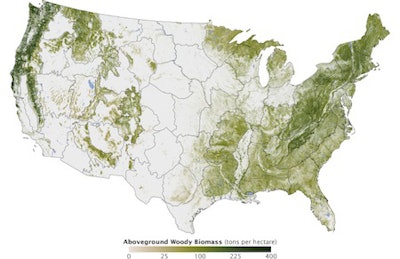
Depicting the concentration of biomass, or organic carbon, a new map from NASA reveals where the leafiest forests and the tallest trees in America are located, which should aid forest managers in overseeing the responsible management of the natural resource that is the backbone of the wood flooring industry.

It took six years and the combined efforts of several government-sponsored research organizations to determine that about a third of the U.S. is currently forested. The data was compiled and released in the National Biomass and Carbon Dataset (NBCD).
"Forests are a key element for human activity," said Josef Kellndorfer, with the Woods Hole Research Center (WHRC), which helped with the project. "Resource managers need to see forests down to the disturbance resolution-the scale at which parking lots or developments or farms are carved out by deforestation. We have to know how much we have, and where, in order to conduct sound management and harvesting."
According to NASA, "Forests in the U.S. were mapped down to a scale of 30 meters, or roughly 10 computer display pixels for every hectare of land (4 pixels per acre). They divided the country into 66 mapping zones and ended up mapping 265 million segments of the American land surface." Kellndorfer said the mapping database includes measurements of about five million trees.
Requests for data access via the WHRC can be made here.


