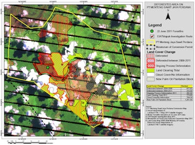

After palm oil giant Kuala Lumpur Kepong (KLK) denied last week that it had violated Indonesia's logging moratorium (on the very day it was enacted), its accuser, the Environmental Protection Agency (EIA), has released satellite images it says further indict KLK.
The images combine land images with satellite data recorded in a forest concession of KLK's on June 22. The NASA-funded satellites use technology called moderate resolution imaging spectroradiometer (MODIS) to monitor for fires and hotspots across Southeast Asia with "high-percentage certainty," according to EIA. The latticed area deemed "Ongoing Process Deforestation" confirms KLK is illegally burning swaths of Indonesia's forests.
"KLK should prove it is not carrying out land burning in its plantation or its denials will amount to no more than hot air," said EIA's Senior Forest Campaigner Jago Wadley.
Image source: NASA FIRMS / MODIS Rapid Response