An Indonesia-based NGO has released a mapping tool powered by Google that lets users visualize forest loss on the island of Sumatra.

The nonprofit Eyes on the Forest, along with the World Wildlife Fund (WWF) produced the map with a grant and technical assistance from Google Earth Outreach. The free online map contains several layers-from forest change, to ranges of rhinos, orangutans, elephants and tigers, to carbon stores-so that users like corporations can attempt to assess whether their products are sustainably sourced "without leaving home by creating their own maps with suppliers' land holdings related to loss of forest, carbon stocks and biodiversity," according to Google Earth Outreach.
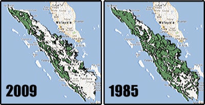
Forest coverage has decreased by nearly 50 percent on Sumatra since 1985, according to Eyes on the Forest. "Our conviction is that if we empower people with the information, the forests of Sumatra cannot only be saved, but we can restore them," said Carter Roberts, President and CEO of World Wildlife Fund. "So instead of rhino, orangutan and tiger numbers getting smaller each year, they get bigger. That's our dream."
This new map from Eyes on the Forest and other Google-backed projects like the remote sensing in action. The technique begins by collecting images of Earth using satellites, or in some instances airplanes. In the case of Eyes on the Forest's new map, the data is first gathered by NASA's Landsat satellite, according to National Geographic, and then passed along to Google for its use in its mapping products like Google Earth.
"As a grant recipient, Eyes on the Forest can use the cloud-based Google Maps Engine platform to share its forest data with anyone," said Tanya Birch, Program Manager for Google Earth Outreach. "Non-profit organizations can simply and easily create custom maps that help their data visually come to life by layering that information on top of Google Earth and Maps."